


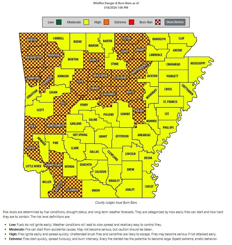
A cold front moving through north central and northeast Arkansas will usher in below-normal temperatures and elevated wildfire danger this week, the National Weather Service in Little Rock says.
Forecasters note that very dry air, critically dry short-term fuels (fine, dead vegetation that has lost nearly all its moisture), and gusty northwest winds are expected to keep local wildfire danger elevated. Dry conditions and winds are raising concerns that sparks or uncontrolled burns could spread quickly, and some counties may be under burn bans as a precaution.
Windy conditions will accompany the cooler air, with gusts near 25 to 35 mph possible Wednesday. High temperatures across much of the region are expected to be in the 40s, while overnight lows may dip into the 20s through the rest of the week and into early next week.
The National Weather Service says the dry weather and generally below-normal temperatures will prevail through the end of the week and into early next week, with little measurable precipitation expected.
To support people without adequate heating or shelter, the First United Methodist Church Warming Center in Batesville will be open Wednesday night from 6 p.m. until 8 a.m. The downtown warming center at 7th and Water Streets will provide dinner and breakfast, as well as shower and laundry facilities.
Local officials remind residents that the combination of gusty winds, dry fuels and low humidity heightens fire risk and to avoid outdoor burning or activities that could ignite fires.
Have a news tip or event to promote? Email White River Now at news@whiterivernow.com. Be sure to like and follow us on Facebook and Twitter. And don’t forget to download the White River Now mobile app from the Google Play Store or the Apple App Store.
Get up-to-date local and regional news/weather from the First Community Bank Newsroom on Arkansas 103.3 KWOZevery weekday morning and afternoon. White River Now updates are also aired on weekday mornings on 93 KZLE, Outlaw 106.5, and Your FM 99.5. Catch CBS News around the top of every hour on 1340 KBTA.