


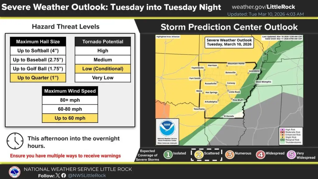
Residents across north central and northeast Arkansas should remain weather-aware this week as forecasters warn of multiple rounds of thunderstorms that could bring severe weather through Wednesday night.
The National Weather Service Weather Forecast Office in Little Rock says a series of weather disturbances moving across the region will interact with warm, humid air flowing north from the Gulf, creating conditions favorable for strong storms.
Forecasters expect showers and thunderstorms to increase in coverage Tuesday afternoon and evening. The primary threats include damaging straight-line winds and large hail, though meteorologists say a limited tornado risk cannot be ruled out.
Another round of storms may develop late Tuesday night into Wednesday as weather systems move east across Arkansas. Some storms could intensify during the day Wednesday, and repeated rounds of rainfall could also increase the risk of localized flash flooding.
Rainfall totals through Wednesday night are expected to range from 1 to 3 inches in many areas, with locally higher amounts possible.
Northeast Arkansas is also expected to see an increase in storm chances. Forecasters with the National Weather Service office in Memphis say breezy conditions and periodic showers and thunderstorms could continue into Thursday, with the greatest potential for organized severe weather Wednesday afternoon.
Officials note the active weather pattern comes during Arkansas Flood Safety Awareness Week. Residents are encouraged to review emergency plans, have multiple ways to receive weather warnings, and avoid driving through flooded roadways during periods of heavy rain.
Have a news tip or event to promote? Email White River Now at news@whiterivernow.com. Be sure to like and follow us on Facebook and Twitter. And don’t forget to download the White River Now mobile app from the Google Play Store or the Apple App Store.
Get up-to-date local and regional news/weather from the First Community Bank Newsroom on Arkansas 103.3 KWOZ every weekday morning and afternoon. White River Now updates are also aired on weekday mornings on 93 KZLE, Outlaw 106.5, and Your FM 99.5. Catch CBS News around the top of every hour on 1340 KBTA.